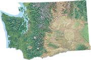
 Lake
Roosevelt, WA is located on the Columbia River above Grand Coulee Dam,
and a National Recreation Area surrounds the lake. The recreation area includes
mainly the lake and its sandy beaches as it extends upland to the "1310 line", a boundary located roughly 20 feet above the lake's high water mark. Many prime spots are accessible
only by boat.
Lake
Roosevelt, WA is located on the Columbia River above Grand Coulee Dam,
and a National Recreation Area surrounds the lake. The recreation area includes
mainly the lake and its sandy beaches as it extends upland to the "1310 line", a boundary located roughly 20 feet above the lake's high water mark. Many prime spots are accessible
only by boat.
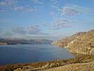
The lake is set in a sunny location surrounded by extraordinary landscapes including a deep basalt canyon forming the northern rim of the Columbia plateau, rock outcrops, shrub-steppe, grassland and ponderosa pine terraces and mixed-forest mountains of the Kettle River Range. The geology of the area is unique, having been covered during ice age times by an even larger lake -- glacial lake Columbia -- and further swept by enormous, powerful floods that carved huge coulees and scablands across Eastern Washington.
 In 1811, David Thompson landed a canoe at a San Poil Indian village near Whitestone Rock. About the area upstream he wrote, "The country always wears a pleasing romantic view, the early part of the day hills and valleys, et cetera, with partly wooded thinly, and partly meadow, the latter the most predominant." Lewis
R. Freeman, who canoed down the Columbia River in 1926, wrote of the area,
"the sun painted the sky and the weird pinnacles and bluffs of the
bleak shore with colourings brighter and more varied than any I had believed
to exist outside of the canyons of the Colorado and the Yellowstone. Saffron
melting to fawn and dun was there, and vivid streaks that were almost
scarlet. ...A fluted cliff-face ... flushed a pink so delicate that one
seemed to be looking through a rosy mist."
In 1811, David Thompson landed a canoe at a San Poil Indian village near Whitestone Rock. About the area upstream he wrote, "The country always wears a pleasing romantic view, the early part of the day hills and valleys, et cetera, with partly wooded thinly, and partly meadow, the latter the most predominant." Lewis
R. Freeman, who canoed down the Columbia River in 1926, wrote of the area,
"the sun painted the sky and the weird pinnacles and bluffs of the
bleak shore with colourings brighter and more varied than any I had believed
to exist outside of the canyons of the Colorado and the Yellowstone. Saffron
melting to fawn and dun was there, and vivid streaks that were almost
scarlet. ...A fluted cliff-face ... flushed a pink so delicate that one
seemed to be looking through a rosy mist."
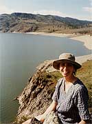
Lake Roosevelt stretches about 150 miles from Grand Coulee Dam upstream to the Canadian border, making it among the largest lakes in Washington State with over over 630 miles of shoreline. The lake level may vary 60 to 80 feet throughout the year and tends to peak in early- to mid-July, meaning less beach then. The lake drops to its lowest level in May to make room for spring snowmelt from faraway mountains that drain to the Columbia River.
The recreation area provides excellent wildife viewing, fishing, birdwatching, photography, stargazing, and pondering. The area also is a fine place for watersports like boating, waterskiing, sailing, windsurfing, swimming and sunbathing.
 The
diversity and solitude of surrounding lands provide habitat for an
assortment of mammals, birds, butterflies and wildflowers, for those who look. Mule deer are common as the lake
marks their migration corridor, and coyotes can be heard howling to each other most nights. Black
bear are also common and once in a while a
The
diversity and solitude of surrounding lands provide habitat for an
assortment of mammals, birds, butterflies and wildflowers, for those who look. Mule deer are common as the lake
marks their migration corridor, and coyotes can be heard howling to each other most nights. Black
bear are also common and once in a while a  moose or elk (or perhaps a
whole elk herd) can be seen swimming across the lake. Bighorn
sheep have been re-introduced to the Lincoln Cliffs and other canyony areas. A variety
of birds live around Lake Roosevelt including osprey, eagles, hawks, merlins, loons, killdeer, and cheerful meadowlarks, tanagers and goldfinches.
By day, mourning doves coo, by evening nighthawks call, and at night poorwills haunt and owls hoot or screech. The area is home to elusive badgers, bobcats and mountain lions.
moose or elk (or perhaps a
whole elk herd) can be seen swimming across the lake. Bighorn
sheep have been re-introduced to the Lincoln Cliffs and other canyony areas. A variety
of birds live around Lake Roosevelt including osprey, eagles, hawks, merlins, loons, killdeer, and cheerful meadowlarks, tanagers and goldfinches.
By day, mourning doves coo, by evening nighthawks call, and at night poorwills haunt and owls hoot or screech. The area is home to elusive badgers, bobcats and mountain lions.
A common activity on the lake is to rent a houseboat to explore beaches and coves, and camp in luxury. The recreation area provides dozens of remote campgrounds, many for camping by boat only. However, boaters should pack a port-a-potty to help keep remote beach camps clean, as most camps have no toilets.
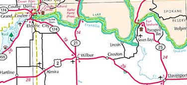
South Half Lake Roosevelt - Click for full map
For more information about the lake and recreation area, the Roosevelt Forum and National Park Service sites listed at the left of the page provide outstanding information. Links are also available to other articles, guides, and nearby wildlife and recreation areas.
Be aware of recent reports indicating heavy metals have been sampled
in lake sediments, mostly concentrated uplake toward the Canadian border
and in the Spokane Arm. Related to this, health advisories recommend limits
to eating fish caught from the lake. Links below cover this health issue
in greater detail:
Lake Roosevelt Sediment
Contamination
Assessment
begins on Columbia River waste
Concentrations and
Distribution of Slag-Related Trace Elements - USGS
Lake
Roosevelt study is no cleanup plan
Lake
Roosevelt beaches are safe, early findings show