This version of the Interactive Washington State map lets you bookmark or link to a custom view with all settings saved in the Web address, zoom in and out and move to different locations, double-click a point to get its latitude and longitude coordinates, and switch between map and satellite image views.
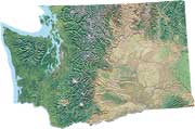
Interactive Washington map
Roads, cities, satellite imagery, and detailed aerial photos
Google Map version
This Washington State map is provided courtesy of Google Maps.
» Washington State maps collection
» Eastern Washington wildlife
» Eastern Washington animals and plants
Washington State map search
Google
Local Search
Microsoft
Bing Local Search
Yahoo Local
Related information
Google Maps API

Together, we can build a place where grass-stains, muddy boots, and climbing trees are parts of everyday life for kids.
© Copyright 2004-2023 All rights reserved