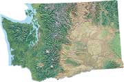
Shaded
relief map of Washington State
Color composite map displaying landforms and land cover to help locate
landscape features, wildlife habitats, and/or other interesting areas
to explore.
- Western Washington shaded relief map
- Eastern Washington shaded relief map
- Printable Washington map - pdf
Washington State road map
Overview of the full-sized road map of Washington State with links to
detailed maps provided free by the Washington State Dept. of Transportation.
Eastern Washington
map of wildlife areas, refuges and parks
Western Washington wildlife refuges, parks and wilderness areas
Index maps to many major wilderness area, wildlife refuges and recreation areas in Washington State.
Washington tourism maps
View or order free printed maps showing points of interest across the state.
Wildlife Viewing Guides and Maps- Washington Dept. of Fish and Wildlife
Central Cascades Geotourism Map - National Geographic
Points of interest in around the Central Cascade Mountains of Washington and Oregon.
Washington
State maps by Department of Ecology
Detailed online maps covering a variety of unique ecological and political
themes, including temperature and precipitation maps, wind and solar energy
potential, major public lands, and population density among others, from
Washington State Department of Ecology. Maps are free of charge.
Washington
State maps and data - scenic byways map
Scroll to the bottom for the useful map of scenic drives across the state.
Washington State
bike maps
Free bicycle trail maps for the entire state from the Dept of Transportation.
The Great
Washington State Birding Trail
Map series from the Audubon Society showing suggested trips through the
state's best birding areas, including best stops to see birds, habitat
descriptions, seasonal bird lists, and how to access.
Interactive map of major
fires
Maps of current range fires and forest fires in Washington
state.
Washington State precipitation map (Acrobat pdf)
Historical
maps and aerial photos - Puget Sound shorelines and rivers
Download old aerial photographs and maps dating to the 1930's and 1940's,
focusing on major river systems draining to Puget Sound and the Puget
Sound shoreline.
Metzker's Seattle
- Washington State maps
Find Washington wall maps including shaded relief maps from Raven, topographic
maps from USGS, oblique-perspective landform maps from Molenaar, satellite
imagery from M-Sat and raised relief from Kristler (for purchase).
Washington
topographic atlas and gazetteer
Moderately detailed book of USGS topographic maps essential for travel
and recreation (for purchase).