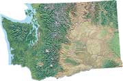
 Escure
Ranch covers about 20 square miles of wide-open, flood-torn landscape
in the Cheney-Palouse Scablands of Washington State. This remote area
straddles the boundary of Whitman and Adams counties south of Sprague,
southeast of Ritzville, and northeast of Washtucna, Washington. Before
the Bureau of Land Management purchased Escure in 1999, Escure was actively
worked as sheep and cattle ranch, and its ranch house, barns, buildings
and corrals still stand, just a short walk from the parking area.
Escure
Ranch covers about 20 square miles of wide-open, flood-torn landscape
in the Cheney-Palouse Scablands of Washington State. This remote area
straddles the boundary of Whitman and Adams counties south of Sprague,
southeast of Ritzville, and northeast of Washtucna, Washington. Before
the Bureau of Land Management purchased Escure in 1999, Escure was actively
worked as sheep and cattle ranch, and its ranch house, barns, buildings
and corrals still stand, just a short walk from the parking area.
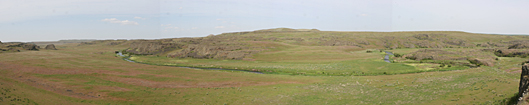
Rock Creek panorama looking north
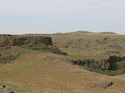
This is a big, stark land. Bunchgrass and weeds, crusty low sagebrush, basalt mesas and big sky give Escure Ranch a lonesome, western feel that would make it entirely fitting for touring on horseback. For roaming, remember to bring a good hat for a little shade from from blazing sun, to help protect your brains from baking. It might also be a good idea to pack a slicker too, for the occasional spring squall or summer thunderstorm, with their terrific winds and pelting rain. Hiking and mountain biking these old ranch roads seems to make space inside the mind to consider long forgotten things, and it's a joy just to be there.
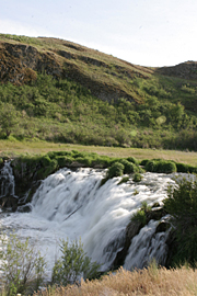 This
area is pocked with marshes, stock water holes and pothole lakes, and
meandering through it is about eight miles of Rock Creek, a catch-and-release
flyfishing stream that has a reputation for producing lunkers. Rock Creek
flows strong and has a magnificent 15-foot waterfall named of Towell Falls
downstream from the ranch buildings. The waterfall is an easy three mile
hike along a jeep road, a good place to see marmots and deer, and to be
watched by hungry hawks.
This
area is pocked with marshes, stock water holes and pothole lakes, and
meandering through it is about eight miles of Rock Creek, a catch-and-release
flyfishing stream that has a reputation for producing lunkers. Rock Creek
flows strong and has a magnificent 15-foot waterfall named of Towell Falls
downstream from the ranch buildings. The waterfall is an easy three mile
hike along a jeep road, a good place to see marmots and deer, and to be
watched by hungry hawks.
Wildlife inhabiting the area include mule deer, coyote, red fox, Nuttall's cottontail rabbit, badger, yellow-bellied marmot, packrat, snakes, a variety of raptors such as kestrel and red-tailed hawk, water fowl and other birds including red-winged and yellow-headed blackbird, song sparrow, horned lark, rock wren, and Wilson's snipe. Butterflies include silvery blue, large marble, silver-bordered fritillary and various skippers.
The area seems a little weedy, maybe from years of livestock grazing, but many wildflowers persist including Douglas' brodiea, Columbian puccoon, marsh buttercup, Gray's biscuitroot, violet, and chokecherry. Some areas grow thick with vetch, perhaps planted as nutritious forage for sheep and cattle.
» Escure Ranch Detailed Topographic Map
Directions from the north:
From I-90, take the exit for SR 23 and go south 8 miles, through Sprague,and
turn right on Lamont Road. In about 2.5 miles Lamont Road bends left and
turns into Revere Road; 8 miles after the turn, go right on Jordan-Knott
Road, then another 2 miles until you reach Rock Creek Management Area,
another right turn. Drive until you reach a parking area with port-a-potties.